Class Name: Continuous Level of Detail Related Geometry
Definition
Used to represent continuous terrain or continuous adaptive terrain, by
replacing a Polygon with a set of fragmented
Polygons that represent the terrain at a finer
level of detail at close range (or alternatively, with a coarser
level of detail at long range).
The general idea is that basic Polygons
have fragmented Polygons within them,
and those Polygons may have
subsequent fragmentation.
Primary Page in DRM Diagram:
Example
A Continuous LOD node can be fragmented into one or more
Polygons, and will then have zero or more
Continuous LOD nodes as subnodes. Any Continuous LOD node that contains
Continuous LOD nodes under it will have the
terminating_node flag set to False. The
Union of Primitive Geometry
node will contain Polygon data. If a Continuous
LOD node is encountered with the
terminating_node flag set to True, that means it only has a
Union of Primitive Geometry
node under it.
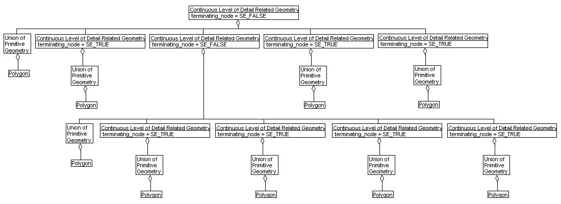
(NOTE that this example only shows two levels of polygon fragmentation.
Each Continuous Level
of Detail Related Geometrycould contain component
Continuous Level of
Detail Related Geometries, but that would make a huge picture. Only the
idea is represented here.)
FAQs
- How do I find the finest fragmentation of polygons?
- Follow all Continuous LOD chains. Wherever a Continuous LOD node with
terminating_node set to True is encountered, that identifies
the finest fragmentation of Polygons under the
Union of Primitive Geometry
at that Continuous LOD.
- So, what do the "terminating"
Polygons represent?
- The combination of polygons from the Continuous LOD nodes with
terminating_node set to True make up the Polygon identified under the
Union of Primitive Geometry
from the Continuous LOD node with
terminating_node set to False.
- How do I tell what the range is between fine and coarse data
without a link class like
Geometry Level of Detail
Data?
- The uniqueness of Continuous LOD data is that it is not based on
range data for an entire area to blend in. Rather, the blending of
data is performed typically at the IG. In source data, all potential
polygon fragmentations have been identified. Therefore, it is not
necessary to have range data stored in a link class.
Constraints
Associated by (one-way)(inherited)
Associated with (two-way)(inherited)
Composed of (one-way)(inherited)
- optionally, some {ordered} Attribute Set Indices
- optionally, a Classification Data
- optionally, some Property Tables
- optionally, some Property Table References
- optionally, some Property Values
- optionally, a Reference Surface
- optionally, some Sound Instances
- optionally, a Spatial Domain
- optionally, a Bounding Volume
- optionally, a Center of Buoyancy
- optionally, a Center of Mass
- optionally, a Center of Pressure
- optionally, some Collision Volumes
- optionally, a Conformal Behavior
- optionally, a LSR Transformation
- optionally, an Overload Priority Index
- optionally, some Property Descriptions
- optionally, a Stamp Behavior
- optionally, some {ordered} Colors
- optionally, a Light Rendering Properties
- optionally, a Rendering Properties
- optionally, some {ordered} Image Mapping Functions
- optionally, a Rendering Priority Level
Composed of (two-way)(inherited)
Composed of (two-way)
Composed of (one-way metadata)(inherited)
Component of (two-way)(inherited)
- optionally, some Alternate Hierarchy Related Geometries through Geometry Hierarchy Data
- optionally, some Animation Related Geometries
- optionally, some Classification Related Geometries through Geometry Classification Data
- optionally, an Environment Root
- optionally, some Geometry Separating Plane Relations through Geometry Separating Plane Data
- optionally, a Geometry Model
- optionally, some Level of Detail Related Geometries through Geometry Level of Detail Data
- optionally, some Oct Tree Related Geometries through Geometry Oct Tree Data
- optionally, some Time Related Geometries through Geometry Time Constraints Data
- optionally, some Perimeter Related Geometries through Geometry Perimeter Data
- optionally, some Quad Tree Related Geometries through Geometry Quad Tree Data
- optionally, some Spatial Index Related Geometries through Geometry Spatial Index Data
- optionally, some State Related Geometries through Geometry State Data
- optionally, some Union of Geometry Hierarchies
Component of (two-way)
Notes
Fields Notes
 If SE_TRUE, then for any object that exists 'below' this aggregation,
 each object will appear in only one 'branch' of this aggregation.
 If SE_FALSE, then objects may appear in multiple 'branches' of this
 aggregation.
 If SE_TRUE, then each 'branch' from this aggregation is its own,
 independent topology.  If SE_FALSE, then all of the branches exist
 within the same topology.
 If true, then each 'branch' strictly follows the rules of this
 aggregation.  If false, then each 'branch' might bend the rules a bit.
 For example, if this is a spatial aggregation, than a value of true
 indicates that objects will *not* cross the spatial extents defined
 by this aggregation relationship, and a value of false indicates
 that objects might cross those bounds.  For another example, if this
 is a time-based aggregation, then a value of true indicates that all
 branches will only contain data valid for the times specified for
 each branch, and a value of false indicates that the branches have
 the option of including data that falls outside of the specified
 time ranges for that branch.
 This flag identifies if the current level is the lowest level of
 fragmentation for a specific chain. Set to SE_TRUE if no other
 <Continuous Level of Detail> nodes are found below this chain's
 current level.
Prev: Contained Within Geometry Face.
Next: Control Link.
Up:Index.